
Planning your first cross-channel trip
 “The thought of skippering your first cross channel passage can be daunting if you’re used to hopping around the Solent. Mileage weekends provide a good opportunity to plan and skipper a passage with the safety net of a skipper or instructor on board. But if you’re ready to charter a yacht and skipper your own cross-channel trip then here are a few tips about planning your passage from the comfort of your living room.
I’ve assumed that you don’t have a full set of Solent and cross-channel charts or an English Channel Tidal Atlas lying around at home so I’ve also recommended some apps that can be used for pre-planning. See our new Apps webpage for more details.
I’ve used Hamble to Cherbourg as an example passage as it is probably the most straightforward cross-channel passage.”
Good luck, Alex.
Chief Instructor, Hamble Point Sailing School
Starting your planning
Once you’ve made your charter reservation, and have set dates, you can start to consider the tides for your cross-channel journey. At this point you can plan to expect the prevailing south-westerly winds but keep an eye on the forecasts nearer the time of the charter and be ready to change your plans accordingly. I’ve used Saturday 22nd August in my example. This date is a little after springs but the range of tide on that date is greater than the mean range so I will need to extrapolate the tidal rates.
Distance and duration
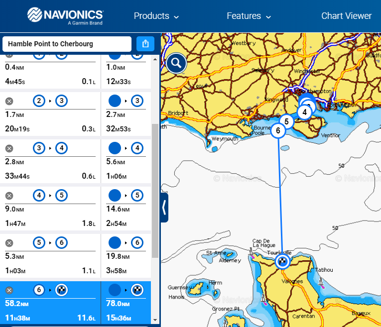
The online Navionics Web App is free to use and is great for basic planning before you have access to the on-board HPYC charts. A quick Navionics route shows that the whole trip, is around 80NM with the longest leg, from The Needles to Cherbourg being around 60NM.
 Assuming a boat speed of 5 or 6 knots this will mean a total journey time of around 15 hours. In all likelihood this will mean that some of the trip will be in darkness hours. For your first crossing, it is a good choice to depart in the early hours and arrive in Cherbourg during daytime. My plan assumes leaving Hamble at an eye watering but sensible 0300!
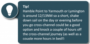
Tides – Hamble Point to The Needles
There are no tidal height constraints between Hamble Point and Cherbourg for any of the HYPC yachts. Therefore, timing wise its simply a case of finding a favourable tidal stream for the 20NM, 3 to 4 hour journey, from Hamble Point Marina and out through The Needles.
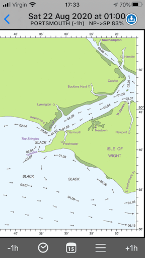
This is where the interactive tidal atlas within the Imray Tides Planner app is incredibly useful. This tells us that the tidal hours of Portsmouth HW to HW+4 are favourable to leave Hamble and exit The Needles. If you choose a specific date then the app will also give you the actual times of the tidal hours.
The animation shows an extract from the app. At the top you can see how easy it is to scroll trough the tidal hours to find a window that works.
 Tides – cross channel
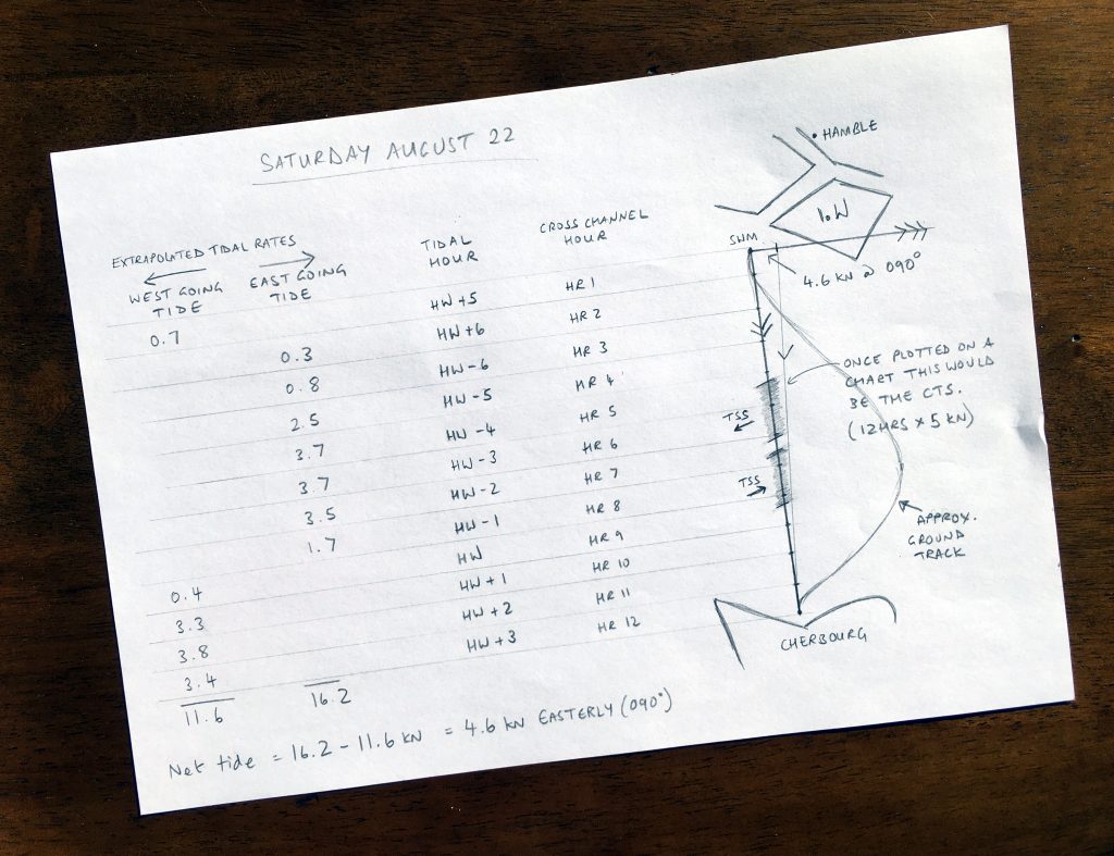
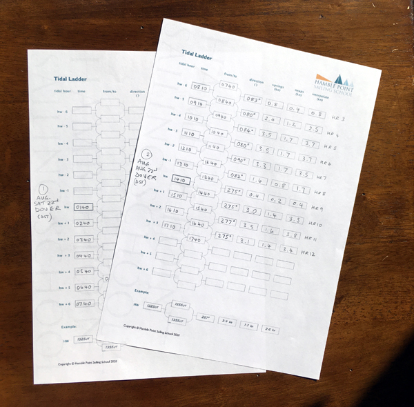
 The cross channel part of the journey, at 60NM is likely to take around 10-12 hours and that’s a lot of tide to consider. In this cross-tide situation the most efficient method is to average multiple hours’ worth of tide and prepare a course-to-steer based on the offset as shown below.
- Work out your likely time, or tidal hour, of arrival at the The Needles Fairway buoy. I’ve assumed arriving here between 0600 and 0700. Note that the cross-channel tidal atlas refers to Dover HW (the Solent tidal atlas refers to Portsmouth HW).
- Find the tidal rate for the next 12 hours (or however long you expect the 60NM passage to take based on your estimated boat speed). You will need to estimate where you will be en-route at each hour. I’ve drawn a very basic sketch of the cross-channel leg and roughly divided it into 12 hours.

- If the date of your intended trip is between springs and neaps then you will need to interpolate or extrapolate the tidal rates. There are various methods:
- This can usually be done using some basic mental arithmetic … springs plus a little bit.
- The textbook approach is to use a ‘Computation of Rates’ table (downloadable below).
- Alternatively, use a calculator. Enter ‘Today’s tidal range’ ÷ ‘Mean springs range’ x ‘Today’s springs rate’ = Today’s interpolated/extrapolated rate (see below).
- Whichever method of extrapolation you have used, the next step is to add up the east-going tidal rates, add up the west-going tidal rates then subtract the difference. This gives you the net tidal rate for the tidal vector of your course-to-steer (once you have access to paper charts).

Other bits of planning you can do in advance:
- If you own the Navionics App you can identify the latitude and longitude of some waypoints and draft some pilotage plans including light sequences for the Hamble to Needles leg. Looking at satellite photos of Cherbourg may also help you to visualise the layout.
- Identify some suitable ports of refuge
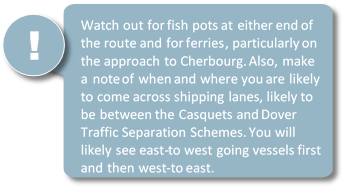
- Plan a watch system (especially if you are getting up at 0200!). It is highly recommended that the skipper is on watch when approaching and crossing the shipping lanes.
- Plan your menu … and maybe a good point in the journey to make bacon sandwiches!
Navigation tools and documentation
The HPYC boats all have the Reeds Nautical Almanac, Admiralty charts that cover the English Channel, a Shell Channel Pilot, a Portland plotter and dividers on board – as well as an electronic chart plotter! The English Channel tidal stream atlas can be put on board on request.
The yachts carry a French courtesy flag (and the ’Q’ flag for the Channel Islands). Every boat has the necessary boat paperwork on board (SSR Registration, insurance, Bill of Sale, VAT status and Ship’s Radio Licence). As skipper, you need to ensure that you carry your Marine Radio Short Range Certificate (SRC) and your sailing qualification such as RYA Coastal Skipper. Every crew member should also bring their passport and, at the time of writing, their European Health Insurance Card. Don’t forget some Euros!
Downloads
WHAT CLIENTS SAY
This is truly a 5 * service. The team really looked after us both ashore on arrival and also while at sea. We were a relatively inexperienced crew but always felt the team ashore had our backs. Thoroughly recommended.
I just wanted to say Thank-you very much for the weekend charter. It was exactly what we were after (albeit cold!) plus Andy was an awesome teacher and great company. We’ll definitely be keen to book again soon!
We had a fabulous four days. Marina is ideally placed for the Solent, boat was in great condition, well equipped and a joy to sail. We were well briefed and the shore side team including the dog very friendly.
We charted one of the sailing yachts for a fantastic weekend cruise in the Solent. The boat was in superb condition and well equipped, the staff was very helpful explaining how things work on the yacht and there was also a video available with all the important information. 10/10 would recommend!
Had a fantastic week chartering Blue Otter, Alex was incredibly helpful and sent loads of information and date checking prior to booking. There was a handover video and both the handover and return were really smooth. The boat was lovely and well maintained and Lee was really helpful in recommending places to visit (and helping identify the steering issue as an autopilot takeover - doh!). Definitely will be back and would fully recommend!
Just back from a lovely week in the Solent. Great service from HPYC from first inquiry through to return handover. Very straightforward to deal with, and the yacht was in excellent condition. We've chartered from many companies in the UK and abroad and the attention to detail (and flawless inventory!) was second to none. Everything about the yacht and equipment had clearly been well looked after and was in immaculate condition. Great service, will use again.
Always very friendly service, and well-maintained yachts. Easy check-in and checkout. Will be back...
We had a great time and were very happy with everything. Your team were genuinely friendly and were very helpful when we needed it. Is a big contrast to many charter companies I have dealt with in the past.
Watching the sun go down with a glass of bubbly on the deck of a sparkling yacht was unbelievable. What a treat, and a much needed change of scenery in these troubled times. We will be back for sure
Fab service, nothing too much trouble, including my daft questions. I'll be a repeat customer for sure!
We had a great time sailing with Lee for a few days at the beginning of September. Hamble Point Yacht Charters supplied us an impeccable 45 ft Hanse yacht, which was handled with complete mastery by Captain Lee. It was a privilege to sail with Lee, who is clearly a highly skilled professional taking great pride in his work ... but who is also a fantastic character with a great sense of humour and plenty of fun stories to keep the whole family entertained. He balances the serious side of safety and learning about sailing with a whopping dose of amusement and good cheer. We sailed the Solent in some decent seas, visited Bucklers Hard on the banks of the Beaulieu River and learned lots about British nautical history. Our boys started somewhat of a fishing trend catching bass off the back of the boat in Portsmouth and we would love to sail with Lee again in the future. The man truly knows his stuff, maintained the boat impeccably and went to every effort to ensure that we had a great time. Many thanks to “Shippers” and Hamble Point Charters. We’ll be back.
Chartered bareboats with HPYC on numerous occasions most recently in Sept 2020. Always helpful and accommodating. Highly recommend.
We had a fantastic weekend sailing on Loxley B. Boat in super condition and spotlessly clean, Alex. and the team very thorough and always on hand to answer any questions. A great experience. We will be back. Thank you!
Lots of information from office with a friendly service. We selected a one of the cheaper yachts and was please with find everything work and was cleaned and tidy. We will definitely be back
This was the first time we had tried chartering and as experienced racing sailors we didn't know what to expect. Covid has closed down all our events this year so this was a chance to get afloat at least once in 2020. What a great experience and Alex and all the Hamble staff could not have been more friendly or helpful. We had a great three days and we will be back !! We would have no hesitation is recommending Hamble Point Yacht Charters.